Well, we’ve lasted a year. And we’re not even close to tired of this yet! Success!
Thanks for your readership, comments, tweets, links, emails, and encouragement over the past year. We’ve been beyond pleased with the interest and support you’ve expressed. Hopefully we’re having some tiny effect on one of our original goals, getting people into the geography of Boston as an interesting place. It’s great to see that we’re not lonely in the category of people who get a kick out of mapping this city. We’ve scored a few features in the Globe and were even interviewed one time! Maps, it seems, are an excellent way to get people thinking about the city in new ways.
Tim and I, your humble authors, almost never see each other (the poor fella lives a thousand miles from Boston), but we maintain our enthusiasm for this website. We know each other from conferences, and indeed the Bostonography plan was formed in October of 2010 at a cartography conference in St. Petersburg, Florida. Then we lived a year-long joke of only running into each other in places besides Boston. We met up in Paris, New York, and Madison before finally managing a Boston summit a month ago. We vowed to undertake a mapping project that weekend, but instead only accomplished our secondary goal of discussing business over frappes. We did, however, both break our single-day Boston walking distance records with a 14.5 mile trek around town, and we even found a map on the ground.
Even though we can’t manage to make a map when there’s such an easy opportunity, our recent posts have mostly been our own maps while links to other things are more commonly in our tweets. But this project isn’t just about our work; we’re very interested in helping spread others’ work and encouraging similar activity. So keep those links and ideas coming!
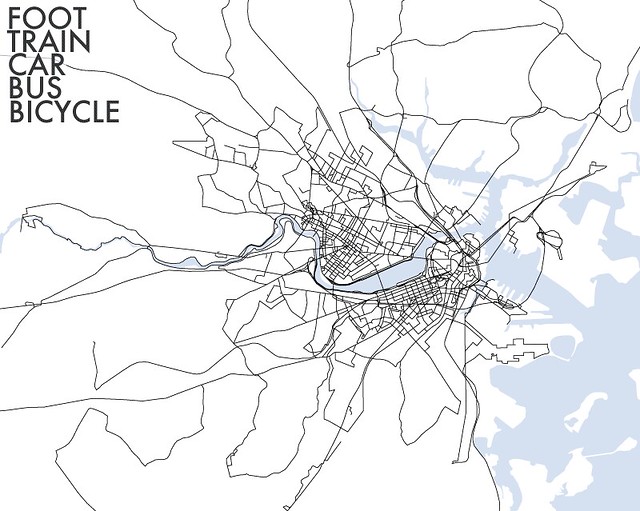
Thanks again, Bostonographers. And because we hate a post without an image, here’s a (different) year of something Bostonography-ish. It’s everywhere I went locally, by all modes of transportation, in 2010.
Congrats on the Big One!
Ok, back to lurking quietly.
Congrats! I’m not a cartographer by any stretch of the imagination but all of this is really interesting to pour through. Also, great info for a newcomer like myself… Thanks!
Very very cool! How did you keep track of all your modes and distances? Automatically? Or do you do it like me (with a spreadsheet and a perverse sense of fun)?
Thanks! Nothing automatic for that map—just careful mental note of my location while moving about, then later tracing it on a map. No spreadsheet either, but still a perverse sense of fun, I think!
Oh, and I love the charts for yourself! Thanks for mentioning them!