There’s a debate—at least in academic cartography—about what constitutes a map. The first lecture in the introductory course at UW-Madison starts with a slideshow challenging students to determine which images are maps and which are not. Among the “traps” designed to trick students into guessing incorrectly are images of a Monopoly board and a 19th century bird’s-eye city view. These, according to our lecturers, are maps. What is not? The only current example of a non-map given in this introductory lecture is that of a photograph (taken at eye-level of Galway Bay, Ireland).
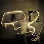
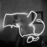
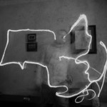
To get into the “what’s a map!?” debate on Bostonography would be moderately to extremely off topic. But I realized yesterday that something I created as a part of my Bogus Art Maps project—according to the introductory cartography course—is a map… and is not. So, I had to make some of Massachusetts.
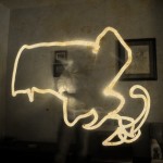
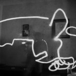
These are light drawings, created using technique that has been around for decades. They are made by taking a photograph in a dark space with a long exposure. While the film is being exposed (or, the sensor in your digital camera is… er, “sensing”) a light source is used to “draw” or “paint” the space in front of the camera. The result is an image that has been “burned” by the path of your light source.
Eat your heart out, Picasso. This is Massachusetts.