Ah, the venerable street map. It is, perhaps, the most common type of map out there in a world of people in motion. From highway atlases to Google Maps, many a map, no matter how complex, is fundamentally designed around streets and the function of finding a way from Point A to Point B via road travel. But to achieve this purposes a street map is never literally just a map of street layout—hierarchies, labels, auxiliary features, and more make it possible. In order to be useful, the design of a street map really doesn’t show you an overall street layout very well.
A beautifully notable alternative is local hero Ben Fry’s All Streets map, which is a marvelously simple map of every street in the lower 48 states. It’s one of my favorite maps for sure, so naturally when I began trying to become acquainted with rendering maps of OpenStreetMap data, one of the first things I attempted was to totally reFry the idea at a more local scale.
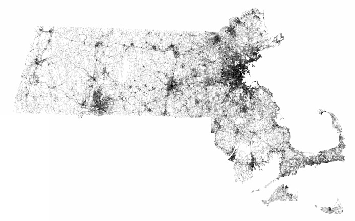
So there is every street in Massachusetts according to OpenStreetMap. Click the image or right here for a tiled version where you can zoom into the map.
The simple presence or absence of streets can imply a number of things, not the least of which is the shape of the land. The coastline and islands are pretty clear. Population distribution is easy to infer, too. In the scale seen above, it’s obvious where population is dense and where it is relatively sparse. Or see the connections between places, for example following the march of towns along Route 2.
Such a map, I think, reveals the chaotic beauty of roads in Massachusetts, at times loved and at times hated. In the distant view there is no orderly geometry to be discerned, and certainly no straight lines. It’s very organic; there are many nodes scattered about with roads connecting them in a tangled web. Zoom in and you might find some of the infamous squares where roads collide from many different directions. All told, you can see why travel by road can be frustrating, confusing, and fraught with delays; but at the same time you can see what lends this fine state and its fine cities a special charm. The streets alone make every place feel unique in a way that isn’t felt amid, say, the rectangular survey systems of the Midwest. You can travel these streets with the confidence that there is always some odd space to discover, and that there are no roads to nowhere.
What, dear readers, do you see in the streets of Massachusetts?

Beautiful!
Also related: Bill Rankin’s map of streets along the US-Canada border.
http://www.radicalcartography.net/index.html?49th
Ooh, that’s another good one! Thanks!
Pingback: Boston: Fair and Square | Bostonography
Pingback: copic coloring guide
Wow this is absolutely incredible. One of the big things that jumps right out to me in just how visible the Southwest Corridor is and how much of a block to cross town automobile travel it is. Really interesting. Thanks guys!