It’s hard to argue that humility is one of Bostonians’ virtues. Hub of the entire freaking universe? Yikes.
No more humble, of course, is the object of our inferiority complex, New York. With massive pride comes a (geographically, at least) narrow worldview, famously illustrated in Saul Steinberg’s 1976 “View of the World from 9th Avenue” New Yorker cover. You may also have seen an earlier map of a similar idea, Daniel K. Wallingford’s 1936 “A New Yorker’s Idea of the United States of America.” (Cartophilia has a bit about this map and some other “inflated views.”)
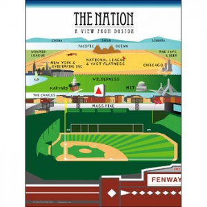
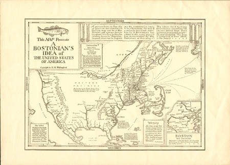
Every place has its take on the Steinberg illustration, of course. There’s the Sox-themed greeting card above, for example, and Tim assures me he has “seen all kinds of postcards and t-shirts of this ilk” (am I just not paying attention?), but there’s nothing nearly as famous as the original. Perhaps for that reason it’s a bit easier to overlook Daniel Wallingford’s other satirical map, “A Bostonian’s Idea of the United States of America.”
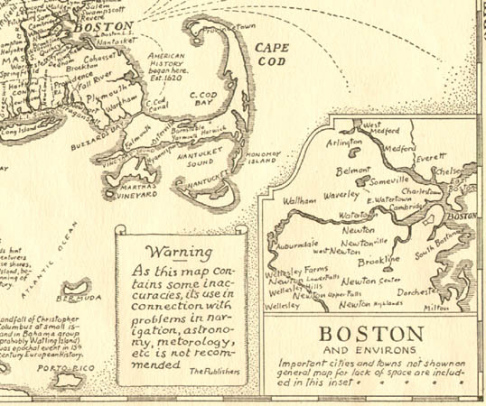
There do not appear to be any decent images of this map on the web; a few old links to the BPL map collection lead nowhere anymore. But we can get the idea. Massachusetts and especially Cape Cod bulge like a flexing arm. Points west and south are unknown, or humorously labeled. (Nice to see that my hometown of Dayton, Ohio at least gets a mention, though.) Otherwise we mostly have to imagine it until a better image turns up.
It’s almost surprising how accurately the Boston inset is drawn; based on some local attitudes I’d kind of expect the Charles River to be more vast and ocean-like, with the distant cities of Boston and Cambridge on either shore. That sometimes seems to be the Bostonian’s view as well as the Cantabrigian’s view. But Wallingford notes that a “Bostonian” can’t be so strictly defined:
A person born in the city of BOSTON and residing in BOSTON may not be a BOSTONIAN; yet a person born in Hingham, residing in Newton (dilatory domicile: Magnolia, frequent crossings to England and the Continent), is likely to be a BOSTONIAN. The lack of a definite text-book definition for A BOSTONIAN has added to the many difficulties encountered by the Publishers of this map.
The ideas held by many BOSTONIANS concerning The UNITED STATES have been gathered, evaluated, weighted, and combined. This map, a composite of these ideas, is the result.
Anyway, check out the links above. There are lots of interesting tidbits to see or read about. Here’s hoping for better circulation and display of this map soon!


It’s true. I did say that I’ve seen all kinds of t-shirts and postcards like the greeting card included here. But I can’t seem to locate any of them, so perhaps I am the one who is not paying attention. In honesty, I haven’t seen them in a number of years. The style was not unlike this work done by Hartwig Braun, but the horizon was composed of far off lands.
Ah! Here’s a postcard that illustrates what I was talking about. Thank goodness I didn’t make this up.
Pingback: East Coast Snob « Singing Stream
Pingback: Life: The Boston Number | Bostonography
My father-in-law has this map hanging on the wall. I’ve always loved it.
Lucky! Do you know where he got it?
There was a poster back in the 1970s that showed the Bostonian’s View of America. Along with the detailed Boston and Cambridge in the foreground, it showed Worcester and Holy Cross, New York City, Chicago and the Mississippi in the middle, and then San Francisco and Hollywood on the west coast. I’ve looked for it a few times online, and never found it. It was always featured prominently in all the bookstores and record shops that sold posters.
This Boston Massachussets of which you speak….is an impostor!! The original is far away and founded well over 1000 years ago. It currently has 60,000 inhabitants..
http://en.wikipedia.org/wiki/Boston,_Lincolnshire
Have fun