In spite of the borderline comical duplication of street names in the Boston area (often within the city of Boston itself), the streets around here are named for many people, places, and things. They are names we encounter every day but rarely think about. Some time ago I heard the idea of making a map indicating the origins of all these street names. It can be a pretty ambitious undertaking for any place… unless someone has already done all the research.
Luckily in my current home, Cambridge, someone has. In 1978 Christopher Hail began assembling what is now a fairly mind-blowing database of the history of pretty much every Cambridge street and building, past and present. It’s truly a heroic effort. If you know Cambridge at all, do yourself a favor and lose several hours looking through it.
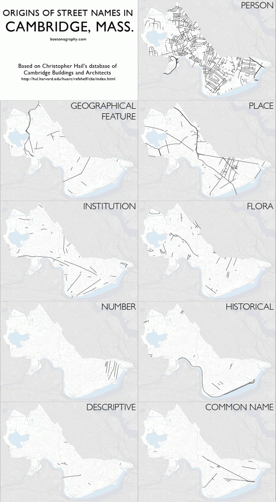
I’ve gone through Mr. Hail’s history of modern Cambridge streets and attempted to categorize them by what they are named for. Here’s a resultant set of maps.
The categories I settled on are briefly described below. It should be noted that there is a small amount of guesswork here; some name origins are uncertain, and not every street fits perfectly in my categories.
- Person. Most streets are named for a person. Often it’s a prominent landowner or the person who laid out the street, and sometimes it’s in honor of someone, like Washington.
- Place. There’s “Massachusetts” and “Cambridge” and such, and then streets named for their destination. But there are also streets apparently just named for other places.
- Geographical feature. Named for rivers, hills, and the like.
- Institution. By this I mean universities, hospitals, or even businesses. Usually the institution is located on the street, or the street runs toward it.
- Flora. Named for a tree, a flower, or what have you.
- Number. First, second, and so on. These, of course, are only in East Cambridge.
- Historical. Named for some historical event or entity. Here I count things like Memorial Drive, named as a war memorial, and other streets that are named for things like Civil War battles.
- Descriptive. The name describes the street itself. Western Avenue goes west; Bow and Arrow Streets form a bow and arrow shape.
- Common name. Those names you see everywhere that don’t mean much in particular. Pleasant Street, Broadway, &c. (Broadway would be descriptive except that it is not particularly broad compared to anything else.)
The idea here was to look for patterns in the street names, but it turns out there are not many patterns. A large majority of streets are named for people, often a local landowner or a military figure—perhaps to the surprise of outsiders, Cambridge streets aren’t all named for Bolshevik heroes. Apart from numbered streets existing solely in East Cambridge, the only thing that stands out in these maps is a group of streets using place names in the Area 4 (at once a lame and awesome name, by the way) and Wellington-Harrington neighborhoods. Many of these are good old and New England names: Norfolk, Essex, and so on.
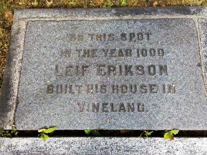
So there’s not so much to see geographically. Some temporal maps would be interesting, perhaps showing the streets in the order they were laid out, or even something based on the lifespans of the people for whom streets are named. In any event, this is a good point of departure for looking into the streets’ history. It can be a little fascinating. Thanks to tiny Norumbega Street, it’s how I learned that Vikings totally landed in Cambridge in the year 1000, by present-day Mt. Auburn Hospital.
Now who wants to map the same for Boston?


Speaking of street names, have you seen this lovely bike ride from Newton, through Allston, Brighton, Cambridge, Somerville, Brookline, and Boston which goes along only streets named Park, Tremont, Washington, Cambridge, Beacon, Harvard, Brookline, or Boylston.
Wow, thanks for the link. That is impressive and fascinating! It perfectly demonstrates how common some street names are, and that they can (almost) be linked like that is the kind of discovery we love around here.
Pingback: Cantabrigian Namesakes - Axis Maps Blog
There were no records kept when streets were named in Boston, so going beyond the obvious street names is very difficult. Often, the names used were not the names of the developer, or any local land owner. Here’s an attempt for Jamaica Plain:
http://rememberjamaicaplain.blogspot.com/2009/07/who-is-that-street-named-after.html
Many more names are of unknown origin. In some cases, I know who developed the street, but have no idea where the name came from.
Yeah, I can imagine it being pretty tough to find out about a lot of Boston streets. Glad to see you’ve looked into this; your Jamaica Plain list is interesting.
Did records for this sort of thing begin to be kept at some point? It’s been interesting from time to time to look through old documents from or about Boston’s Street Laying-Out Department, but I’ve only seen records of the where and when, and also name changes, but not the why of the names.
Older street names are actually easier. Fewer people lived in the area, so surnames are easier to identify. By the 1890s, when the city was filling in, names pop up that have no connection to previous landowners or the current owners developing the streets. Surveyors plans sometimes show up with deeds at the Registry, but even those rarely tell you anything.
In Jamaica Plain, there are two small residential streets in a row – Spalding and Anson. Two of the most famous baseball players of the late 1800s were Cap Anson and Albert Spalding. Could the streets have been named after them on a whim? Could be, but we’ll never know.
I live in the West Fens, a sub-neighborhood of The Fenway (a name that apparently originated with the BRA during the 1960s). Few Bostonians seem to recognize that our street names continue the alphabetical and anglophilic pattern of the Back Bay’s alphabet streets. Most everyone knows the A(rlington)–(H)ereford sequence. If you jump over the Muddy River, a boundary that predates the Bowker overpass, the pattern continues this way:
Ipswich
Jersey
Kilmarnock
Lansdowne
Marlborough (today only in Back Bay)
Newbury (actually continues west of the Muddy River to Brookline Ave.)
O?
Peterborough
Queensberry
Not sure what the “O” street might be (Overland is the obvious candidate, but its location and the name itself don’t fit the pattern). Many of the rest and quite a few of the A-H streets) are British earldoms, as noted at http://www.bostonzest.com/2010/09/the-time-travelers-boston-streets-part-one.html
For a really thorough discussion of the alpha streets, with lots of good links to historical maps, head here> http://www.archboston.org/community/archive/index.php?t-3468.html
Thanks for the info and links, Steve. I saw that fascinating archBOSTON discussion a while ago and by coincidence was just the other day telling some visitors how the alphabetical streets continue over there in the West Fens. Pretty sure they didn’t care, those jerks!
Lucky, having someone do the hard stuff for you =). I’ve thought about making such maps, too, but I never wanted to spend months digging into the origins of (in my case), thousands of town names.
There are some interesting clusters in Cambridge: Heroes from the War of 1812 in Cambridgeport (off of Magazine St.), an area developed soon after the war. Streets named after colleges in the MIT area (so named before MIT located there). Cross streets named after Mass. governors, also near MIT. Early 19th-century cartographers in the Kendall Square area. And the aforementioned Mass. counties (Norfolk, Worcester, Essex, etc.) in “Area 4” and again in the area north of Hampshire St.
Garden St. went to the old Botanic Garden, so that was named after a place, not flora.
Thanks for listing those, Charles. It has been so long since I actually read through all the street information (I put them into those categories maybe a year ago) that I’ve forgotten the clusters like that, except the several memorable Norse streets. It’s fun to find such themes among street names; seems every city has at least a few.
As for Garden Street, not sure why I chose flora for that; under my rules it probably would be an institution, but perhaps I changed it since the institution itself more or less falls in the flora category.
As a long time Cambridge resident and designer/architect, I’m loving the insight and analysis you guys are bringing to our home. It will to impossible for me to look at the street names in quite the same way now. Keep up the good work!
Thank you for the kind words! Sounds like we’ve done our job successfully!
I first came across the NHS page on Vikings in this area a few years back. Fascinating story, but sadly there is zero evidence of vikings ever coming this far south down the atlantic coastline. But a beautiful piece of local color!
Pingback: Names of Places « The American Mystery Deepens