Our friend Derek Watkins recently made a map which he claimed copied something I once did (although he did it much more beautifully), so why don’t we return the favor? He also made a few other maps of Portland, Oregon for the new extent(PNW) blog he’s running along with Nick Martinelli—you should check it out because it’s kind of like the Bostonography of the Northwest—and although those additional maps seem to be inspired by formerly local cartographer Bill Rankin, they have in turn inspired a few quick maps right here. (Because honestly we haven’t found much time lately for maps that involve more than copying someone else.)
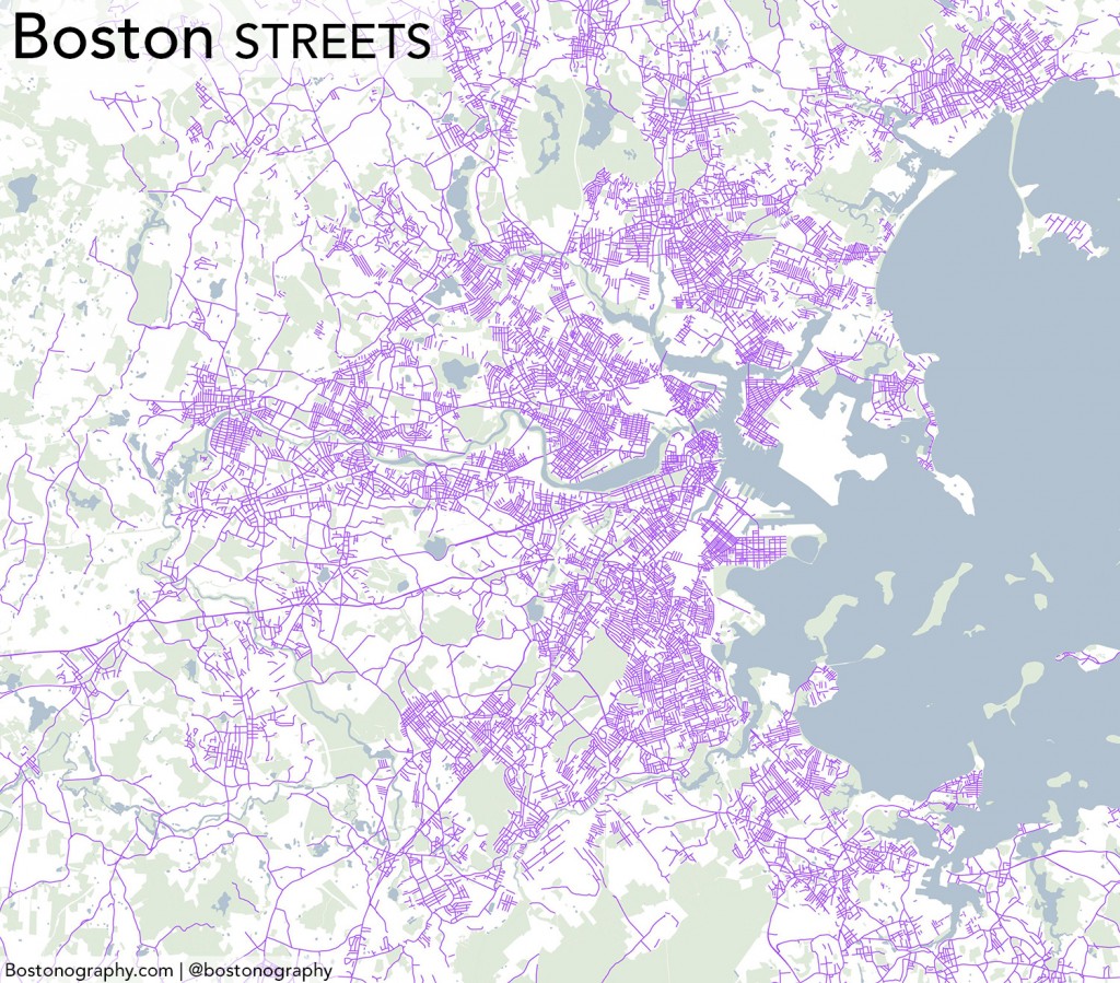
Anyway, what we’re interested in is street names again. This time it’s the type of street: Street, Avenue, &c. Some cities, like the Portland that Derek mapped, have very orderly patterns of streets and avenues, but “orderly” is not a word that is often used with Boston streets outside the Back Bay or Southie. Still, there are patterns. Have a look:
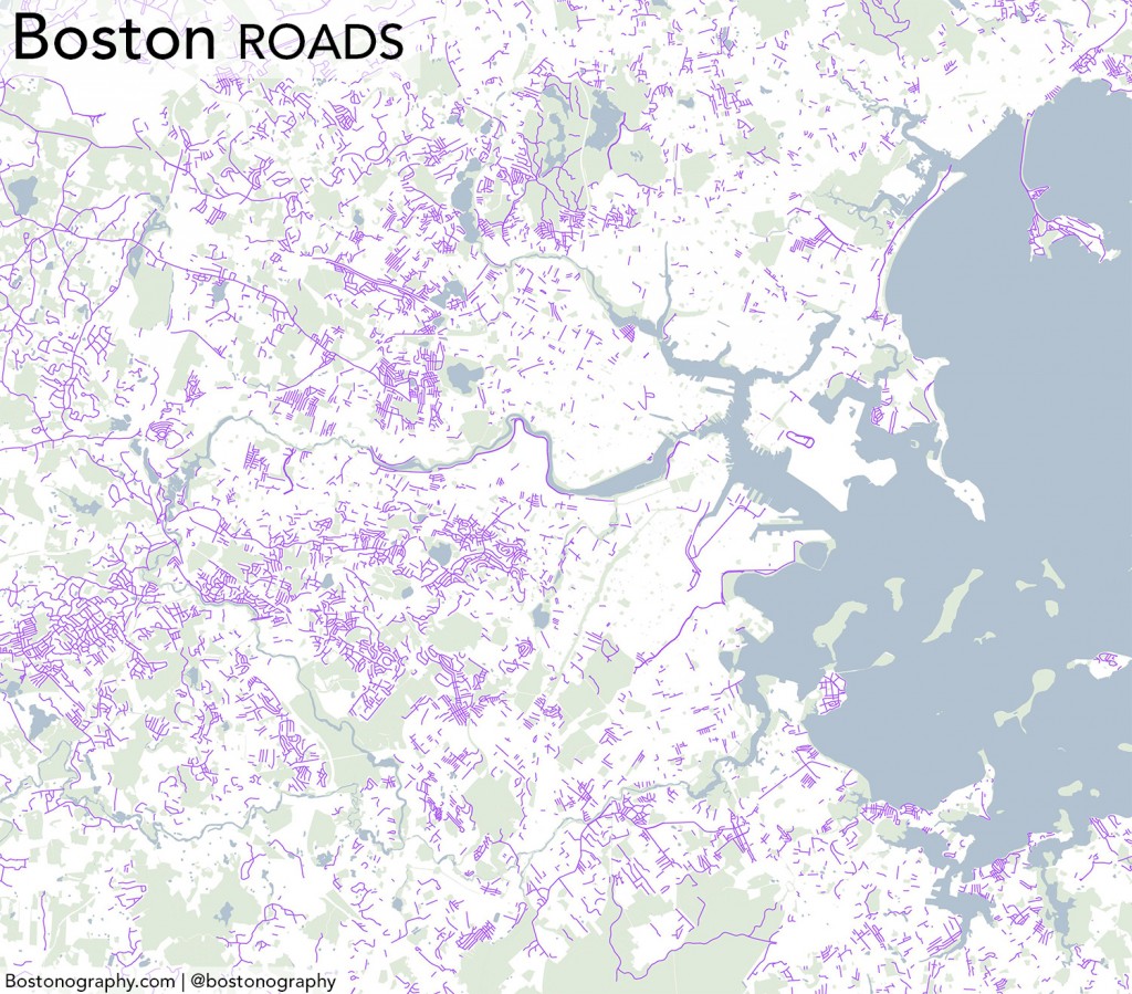
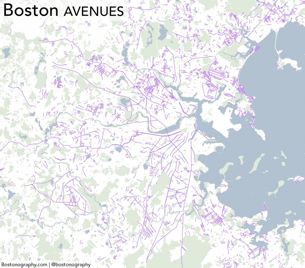
Streets, Roads, and Avenues seem to account for the vast majority of street names in the immediate Boston area. Streets clearly occupy most of the central cities, while Roads are a bit more prevalent in the suburbs, especially toward the west. Avenues, meanwhile, dominate some small pockets and comprise a few notable long roads, but otherwise are not nearly as popular.
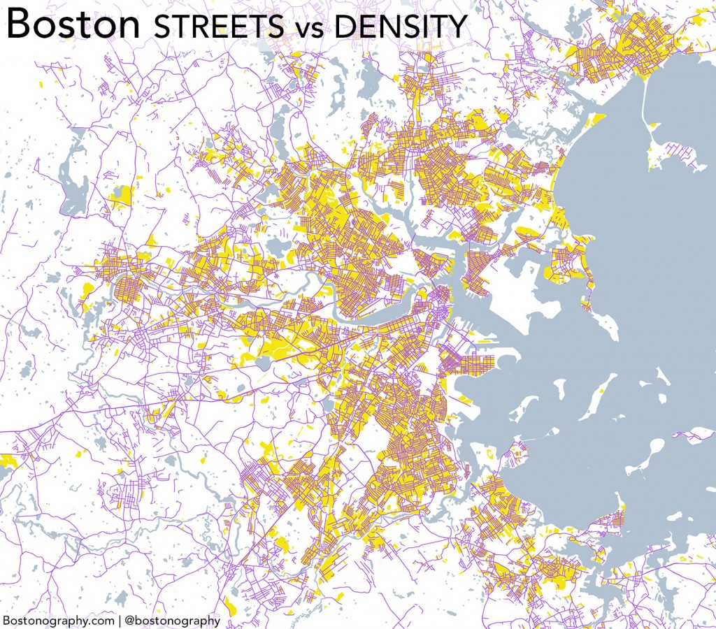
Having looked at enough maps of the Boston area day after day, something that struck me was how well the “Streets” map seemed to correspond to population density patterns, which can also be seen in aerial images. While we haven’t gone so far as to draw any statistically meaningful conclusions, a visual glance does suggest decent correlation. Here you can see the Streets again with population density greater than 10,000 per square mile shown in yellow in the background:
It seems clear that “Street” is the type that dominates urban areas much more than elsewhere. To me this makes some sense. The several types suggest different characters: Roads are long paths between disparate places; Avenues are broad, less organic thoroughfares within a city; and Streets are the smaller urban ways. What do you think? Does this hold true in the Boston area?


Other way names in Boston
“Person Name Way” is nearly always within a public housing development.
Lane is usually an alley, as is Alley. (Seaport Lane is an exception, in a nest Seaport Whatevers.)
As in most cities, Broadway has no suffix, since it’s self-referential.
Boulevard is not much used in Boston: Melnea Cass, Morrissey, Harbor Point, Seaport (portion of Northern Ave).
Place, Terrace are typically dead-end closes (or sometimes jug handles) off a street of same name.
It perhaps would be interesting to plot everything else as a 4th image?
Avenue Louis Pasteur not accounted for?
Ah, good catch. Same for Avenue de Lafayette downtown. Guess I only searched for “Avenue” at the end of the name.
It would be neat to see a map that somehow captures how every single city and town in Massachusetts seems to have the same set of street names. Clarendon, Boylston, Highland….
Indeed—actually that was the initial avenue (ha!) I had gone down with all of this. Here, for example, is Washington. It may be the most common name, or at least the most visible because of the street lengths.
A couple of other quirks worth noting:
1. Add to Broadway Boston’s unique (to me, anyway) set of geographically based but self-referential “ways,” such as The Fenway, The Riverway, The Fellsway, The Jamaicaway. These four seem park-related and maybe even Olmsted-park-related. Are there others?
2. Drives, which I generally think of as suburban, have at least three prominent urban representatives: Park Drive, Storrow Drive, Memorial Drive.
Also, as a Fenway resident, I’m especially aware of the city’s history of renaming roads for various reasons. Both Park Drive and Symphony Road began life with other names (as Audubon Drive and Batavia Street, respectively). Both were renamed in efforts to rehabilitate/whitewash unsavory reputations—Batavia Street as a red-light district, Audubon Drive as a choice location for upper-class men to stash mistresses in pieds-a-terre. Do we have other instances of this going on, perhaps for other reasons, in Boston?
Streets are for everyone (“complete streets,” the Livable Streets Alliance) and roads are for cars. While naming something “Smith Road” as opposed to “Smith Street” doesn’t mean it has to be a street or a road, it would make sense that more streets end up in dense areas where they get used by everyone – pedestrians, cars, cyclists, public transit, etc. – and more roads end up in suburbs where they get used primarily by cars.
also missing are highways – Cummins, American Legion, McGrath, etc…
@william ricker: in the land of the rotary – there’s the “parkways” – vfw, west rox, mystic valley, alewife… IMHO – definitely an omlstead connection.
I wonder if this might be relevant: http://londonist.com/2012/08/why-theres-not-a-single-road-in-the-city-of-london.php
Although the term Road was in use well before Boston came about, perhaps adoption was slow? The comments on the article shed some more light too on the difference in meaning. Perhaps comparing woth city boundaries over time might be interesting too.
It would be interesting to do this map for the UK, or just metro London. The above poster links an article describing how there are no roads in the actual City of London, but the article doesn’t mention the real reason, which is that a road in the original sense connected two locales to each other, and roads were named accordingly. You can see this in metro Boston as well in the older roads ie Dover Rd, Sherborn Rd etc… In old books and texts they are usually referred to with an article, ie, “The Mile End Road” or even “The Road to Mile End”. Streets were named after the businesses associated with them, or after the principal property holder there. In modern America, my experience has been that “street” seems to have some sort of negative connotation (too suggestive of urban-ness?) so suburban subdevelopments seem to use “road” more frequently… along with all those hideous appellations like, “court”, “circle” etc. At any rate, a metro-London map of roads only would basically end up showing all the principal long-range routes from olden times.
Pingback: Boulevard, Avenue, Road, and Street in Detroit | DETROITography