Observe Memorial Day (within 2 miles)

Whoops: Dunkin’s are Closer

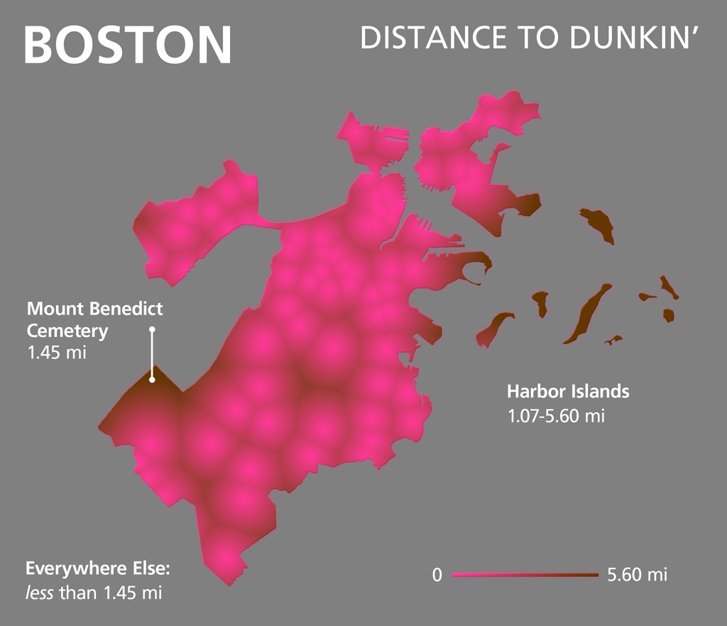
Thanks to Universal Hub for pointing out one of the missing Dunkin’s in our earlier map. Here is a revision. How’s this for irony – the farthest place from a Dunkin’ in Boston is a… cemetery? What was that other map we made?

A couple of caveats:
1. I’m sure we’ve missed some more Dunkin’s (certainly didn’t get all of the airport locations exactly, for example).
2. There is a small area north of the cemetery that seems to be farther from the closest Dunkin’s, but the Cemetery is the only place in the neighborhood in the GNIS.

Bookmark the permalink.

9 Responses to Whoops: Dunkin’s are Closer

  1. Cool! I made a similar Donut Map of what I called “Donutowns” for the current issue of Architecture Boston magazine:
    http://www.pasteinplace.com/#1359782/Redraw-Reboot

    Are your distances measured as the crow flies or distance traveled on streets?

  2. Tim Wallace says:

    Hi Ryan,
    Nice work! Thanks for sharing that link. Those maps look slick.

    No network analysis was done on these Dunkin’ maps (though I’m tempted to do some and make a map of Boston street segments coded by network distance to closest Dunkin’). Instead, this is a simple euclidean distance image. So, unless the crow flies strictly above roads, I think it’s fair to say this is “as the crow flies”. I did mention this briefly in the original post (which was more about Memorial Day weekend than donuts), but neglected to reiterate here.

    Tim

  3. Hi Tim,

    Gotcha… I got here via twitter, so haven’t made my way back to your main article yet! I’d love to see the network analysis. It seems like that type of map would be useful in so many contexts. I’ve been trying to find an easy way to do that for urban design projects over the past few years because it’s frequently important to show areas within a 5 minute walk or 10 minute bicycle ride—but I haven’t found a good way yet (I’m not a gis wiz!).

    Best,
    Ryan

  4. Joel Thibault says:

    Does this account for Dunks outside the city limits? Mt. Benedict Cemetery might be closer to one in Newton or Brookline.

  5. Tim Wallace says:

    Hi Joel,
    It sure does. If you have a look at the city line in Brighton, you can see that the closest Dunkin’ is often outside of the city (this is where the edge is pink and fades to brown within the city limits). I used the locations of 175+ Dunkin’ Donuts in the metro area. Did you have a particular Dunkin Donuts in mind?
    Tim

  6. Pingback: Acorn Donut Holes | Made From Pinterest | Food

  7. Wow, wonderful weblog structure! How long have you ever been running a
    blog for? you made running a blog glance easy. The
    full look of your site is excellent, let alone the content!

  8. Pingback: Tim Wallace to GeoHipster: “Try to get the whole picture before you criticize” - GeoHipster

  9. BestJanell says:

    I see you don’t monetize bostonography.com, don’t waste your traffic, you can earn extra cash every month with new monetization method.
    This is the best adsense alternative for any type of website (they approve all sites), for more details
    simply search in gooogle: murgrabia’s tools

Leave a Reply

Your email address will not be published. Required fields are marked *